Enhancing Policy and Engagement in the Delaware Basin
This program, supported by the William Penn Foundation, concluded on January 31, 2025. If you are interested in supporting this work, contact Colleen McGuire.
The Delaware River flows through four states–New York, New Jersey, Pennsylvania, and Delaware–before reaching the Atlantic Ocean. Consequently, the water policies developed by each of those states, as well as by the Delaware River Basin Commission (DRBC), have an impact on the river’s health and its ability to support sensitive uses like fishing, swimming, and drinking in each and every downstream town and city. The cumulative impacts of water quality threats–including land uses that cause nonpoint source pollution; wastewater and stormwater pollution; and loss of forests, wetlands, and streamside buffer zones–are evident in the degraded health of the river. Public engagement in water quality policy is an effective tool in ensuring these threats are recognized and that action is taken to protect our river and streams.
Throughout the Delaware River Basin, River Network, with support from the William Penn Foundation, focuses on:
- Increasing the understanding and application of policies
- Promoting civic engagement and policy change
- Improving data management and visualization
We work closely with groups throughout the basin to help build capacity of staff and volunteers in each of these areas through presentations, trainings, resource sharing, and one-on-one support. The Delaware River Basin is fortunate to have so many impactful and passionate people working for the health and safety of its river and streams. River Network works to promote collaboration among basin groups to catalyze effective policy changes and community science to benefit water quality.
Connecting the Clean Water Act to Recreation
In the 1970s, the Clean Water Act (CWA) assigned every state and US territory a responsibility to identify and “designate” the uses and intended uses of all the water bodies within their jurisdiction. “Uses” include categories like swimming, fishing, and drinking (learn more and see how waters measure up across the region here). The designations dictate the levels of pollution permitted upstream and informs which activities are allowed on the banks. Beginning with this foundational step of the CWA, states began a process toward today’s cleanup successes, increasing recreation opportunities like swimming and boating for many urban rivers.
Each state varies in its approach to applying the CWA, which can create an added layer of complexity in multi-state basins like the Delaware. River Network lays the foundation of the CWA in this paper on Recreational Uses in the Delaware River, covering basic information about the structure of water quality standards, and how designated uses, water quality criteria and the antidegradation programs in each Basin state and under the authority of the Delaware River Basin Commission play out specifically in regard to the proverbial “swimmable and fishable” goals of the Clean Water Act. Resource Media and William Penn Foundation created the story map below, where you can see which designations and criteria apply to your Basin state.
Local Leaders: Putting Data to Action
River Network is working with several watershed and community groups that are collecting data and information about watersheds within the basin and converting findings into action. Because they live and work in their watersheds every day, their local perspective is valuable in the protection and restoration of the health and uses of the waters and should inform management of these waterways.
Bartram’s Garden: Water Quality Monitoring to Inform Regulations

Photograph by Alan Brian Nilsen.
Bartram’s Garden hosts a community boating program at their southwest Philadelphia location. Under the guidance of Chloe Wang (pictured here) and Joanne Douglas, volunteers and high school interns collect bacterial counts and other data to better understand the risks to boaters in the Lower Schuylkill River. Read about how they put their data to action here.
Musconetcong Watershed Association: Data Dashboards
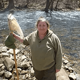
Photo courtesy Musconetcong Watershed Association.
Nancy Lawler (pictured here) and the Musconetcong Watershed Association, through one-on-one trainings with River Network, have created data dashboards to better display their data to the public. Read about how we approach data management and visualization, and check out Nancy’s dashboard here.
River Network performed a basin-wide comparative analysis of a number of Clean Water Act and Safe Drinking Water Act tools, policies and programs in New York, Pennsylvania, New Jersey, and Delaware, specifically as they relate to the Delaware River Basin. Our charge was to identify gaps and opportunities for stronger and more effective water programs. Our high-level review indicated low public involvement by individuals and organizations in the available public comment processes, emphasizing a need for groups like River Network to identify public engagement opportunities in the water quality regulatory process and to train and support those seeking to participate in them. Read the full report here.
In response to these findings, River Network and the Coalition for the Delaware River Watershed created a webpage that highlights open public comment opportunities in the Delaware Basin and provides information and resources for those interested in learning more about how to get involved in the Clean Water Act’s regulatory processes. Access the webpage here.
Want to dive deeper? Check out our “Water Quality Standards of the Delaware River Basin” session, recorded in October 2020, with speakers from the Delaware River Basin Commission, The Watershed Institute, River Network, and University of Maryland’s Water Finance Center.
Bartram’s Garden: Water Quality Monitoring to Inform Regulations

Photo courtesy Bartram’s Garden
In addition to supporting public boating and fishing programs, Bartram’s Garden Community Boathouse volunteers and high school River Interns conduct water quality monitoring on the Lower Schuylkill River. The Lower Schuylkill River is a tributary to the Delaware River and is currently designated for secondary contact recreation (activities like boating and fishing). However, with public kayaking programs, the risk of direct water contact is fairly high which elevates the existing recreational use category up to primary (activities where the risk of water consumption is high, such as swimming) – triggering greater protections. Bartram’s main concern is the safety of their boaters. They have deployed a water quality monitoring program that collects bacterial counts to assess when the water is “swimmable” following rain events and the resulting combined sewer overflows, which frequently cause them to cancel programming.
River Network, in partnership and coordination with PennFuture, developed and delivered policy trainings to Bartram’s Garden staff and data-to-action training for the volunteer monitors. Given the secondary recreational use designation and the existing primary use, Bartram’s could put their data to good use by sending it to the Pennsylvania Department of Environmental Protection (PA DEP) and the Delaware River Basin Commission (DRBC) to help inform their regulations. River Network and PennFuture supported the submittal of Bartram’s Garden data, analysis and supporting materials to DRBC and PA DEP for their review and consideration.
Volunteer monitoring programs educate and engage the public, while collecting meaningful data that can be used to inform the state of the watershed. River Network supports groups throughout the Delaware River Basin in data management and visualization – moving beyond data collection and focusing on analysis and visualization to eventually share and communicate the data in ways that can inform policy, outreach, and future planning.
River Network teamed up with Princeton Hydro, LLC to provide guidance for effective data management, tools for data analysis and visualization, tips for how to communicate data to different audiences. Using no or low-cost tools, there are a multitude of ways local groups can visualize and use their data for action. Check out more of River Network’s Data Visualization resources here.
Musconetcong Watershed Association: Data Dashboards
River Network worked with Musconetcong Watershed Association (MWA) to organize their existing data sets and display them for the public using Google Data Studio. The example dashboard we created shows a summer sampling season of bacteria data for the MWA:
Additional Resources
- Data Products and Visualization Tools for the Delaware River Watershed
- Fishable Swimmable Waters, from William Penn Foundation
- “Onward! Keeping Up the Momentum in the Delaware River Basin” River Network blog post by Colleen Walters
- “River Network Helps Map Waters for Recreation” River Network blog post by Gayle Killam
- “A Letter from Bartram’s Garden to the Pennsylvania Department of Environmental Protection” River Network blog post by Carly Schmidt
- Meet Your Network interview: Joanne Douglas
- Meet Your Network interview: Chloe Wang