River Network Helps Map Waters for Recreation
What is more refreshing than jumping into a river or lake on a hot day? In many urban areas, we are seeing a resurgence of interest in swimming and boating in waters that have long been considered off limits. Our urban rivers suffer from a bad reputation because they have been subject to decades, if not more than a century, of impacts including sewage, industrial waste, all sorts of trash, and other legacies of working rivers that limit access and result in unsafe conditions for swimming.
It’s our job to help ensure local groups have the knowledge and capacity to advocate for safer waters for people and wildlife—with the help of the Clean Water Act. In the 1970s, the Clean Water Act (CWA) assigned every state and US territory[1] a responsibility … to identify and “designate” the uses and intended uses of all the water bodies within their jurisdiction. “Uses” include categories like swimming, fishing, and drinking. The designations dictate the levels of pollution permitted upstream and which activities are allowed on the banks of the stream. Beginning with this foundational step of the CWA, states began a process toward today’s cleanup successes, increasing recreation opportunities like swimming and boating in many urban rivers. Each state varies in its approach, providing an important opportunity for groups to check in on what their state is doing and advocate for improvements.
In my home city, Portland, Oregon, the idea of the Willamette River as a “human habitat” has taken hold because of the creative and tireless energy of the Human Access Project (HAP). With a mission to get people back into the water, HAP created “The Big Float” across the river, and a “River Huggers” Swim Team to fuel their “riverlution!” Similar efforts have occurred in Boston’s Charles River, the Chicago River, and the Ohio River.
River Network’s Delaware River Basin Map
River Network works with organizations in the Delaware River Basin to celebrate and build on water quality successes and to envision a renaissance of riverfront access and recreation similar to the one on the Willamette. In support of this effort, the William Penn Foundation has embarked on an initiative to achieve “25,000 miles of fishable and swimmable Delaware River.” As part of this collective effort, River Network developed an interactive story map to illustrate “designated” waters for swimming and aquatic life in the basin states of New York, Pennsylvania, New Jersey, and Delaware.
The goal of our story map is to translate regulatory details into digestible information that many more organizations can use in their day-to-day work. River Network encourages broader engagement in the regulatory and permitting processes because they have such a profound impact on the work we all do in watersheds across the country.
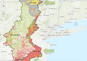
All waters in the Delaware River Basin are designated for swimming except in a 27-mile reach through Philadelphia. The “Recreational Use Support” map depicts where water quality, namely bacteria levels, are too high to safely allow for swimming; this determination is based on the likelihood that individuals may ingest a certain amount of water when they are swimming. More waters upstream of urban areas in less developed areas are impaired for swimming or “recreation” than you might expect. That means that the amounts of bacteria found in those segments of stream have repeatedly been higher than the levels established as protective for human health.
Each state assesses their waters differently. In this map, it is notable that all the waters in grey in New York and New Jersey (and not depicted at all in Pennsylvania and Delaware) have not even been assessed. Therefore, we do not have the full picture of the percent of waters in the basin that meet the requirements for safe swimming. This is not an uncommon reality across the country. States must direct their limited resources for assessment, and they often do so in areas with greater problems or development pressures, leaving big data gaps. Most states tackle more detailed assessments in a multi-year rotation of basins around the state. The Environmental Protection Agency (EPA) summarizes data from states in various forms. From these EPA databases, you can look into assessment results and regulatory information such as permits and clean-up plans (Total Maximum Daily Loads).
What About Fishing?
Our story map also depicts the cold and warm water fish designations and the state assessments of those designations, as well as special high quality designations that afford additional protections.
This same information is available for every state and territory. Some tribes establish and assess water quality standards. Recently, the EPA established and codified a process for tribes to take full responsibility to assess and develop actionable plans to clean up their waters under the Clean Water Act. Tribes have long been taking care of the waters they depend on, yet this official step provides an additional tool for tribes to influence the activities that states and other upstream entities may have on their waters.
You Know Your Waters Best
Data from the states and EPA may not accurately portray what you know to be true in your waters. A stream that is not designated as “Cold Water Fishery” or “Trout Spawning” does not mean fish are not there! Water that is listed as having the quality to support swimming or cold water fish does not mean that it actually has sufficient quality. Fact checking the designations and assessments is where you come in.
There is a regular process for your input that varies by state. River Network believes it is important for more people and organizations to share what they know about how people, fish and other aquatic species and wildlife are using the waters. Look to your state and tribes for (1) the public notice of the Triennial Review of Water Quality Standards to propose changes to designations and (2) the public request for information for the Integrated Report on supported uses and impaired waters. The Integrated Report is supposed to be submitted to EPA in April of every even year. Neither of these processes happens consistently in every state. Your inquiry may contribute to a more regular process if they know the public is paying attention.
Important questions include:
- Where have you seen people swimming?
- Where have you seen people fishing and taking the fish home for dinner?
- How often does your state assess the waters you care about most?
- What is missed during the time they are not assessing – for example, seasonal pollution sources or stressors? What do you know that they might not?
Because the designations of waters dictate what levels of pollution may be permitted upstream and what activities are allowed on the banks of the stream, the designation and assessment process is critical.
If you run a boating program or a streamside education program, you will want to understand those levels of pollution and whether the water quality to protect the recreational uses is met to ensure the health of those participating.
If you are working on a restoration project, the allowed pollution levels may affect the goals of your restoration. In addition, your restoration project may play an important part in a plan that has been developed to improve water quality without you even knowing! Find out whether a Total Maximum Daily Load is in place or scheduled to address problems in the stream.
If you are conserving land, similarly, the allowed pollution levels and current conditions will affect your plans for the property. Perhaps by conserving the land, it would become appropriate to petition to upgrade the use to a more protective level as habitat improves or polluting activities are stopped.
Map Your Waters!
If you are interested in a similar map in your watershed, please contact us.
[1] The CWA required EPA to establish a process for tribes to obtain “Treatment as State (TAS)” for Clean Water Act programs. However, those processes were not initiated until the 1990s and as recently as 2016 were still being developed and clarified.

Look at my Facebook page. Dep. selling permits without oversite. Fighting for years. Any ideas?
Nancy T. Adams